Monitoring saline intrusion in the Ayeyarwady Delta, Myanmar, using satellite data
Country
Myanmar
Description
Myanmar’s agricultural sector, which contributes to most of the country’s gross domestic product has great potential. After the government supported the installation of irrigation facilities in 1992, the double cropping system became widespread in Myanmar, and rice production and population both increased in the well-irrigated lowlands of the Ayeyarwady Delta. However, despite the presence of irrigation facilities, rice cropping is impractical near the coast because irrigation water is severely affected by high salinity during the dry season, limiting crop growth and rendering the soil unsuitable for many crops. Therefore, saline intrusion is one of the biggest factors limiting crop production in the Ayeyarwady Delta.Previous studies based on remote sensing have related the optical variables of water color, such as salinity, turbidity, and suspended sediment concentrations, to single spectral bands. These empirical models are often region- and time-dependent and thus should be calibrated and validated with data that cover a wide range of field conditions. This means that models need to be developed for specific water bodies or sensors. The aims of this study therefore are to (1) develop empirical models by fitting field measurements from three rivers (i.e., the Pathein, Ywe and Pyamalow Rivers) and two sampling occasions (i.e., beginning and end of the dry season) to Sentinel-2 imagery, (2) monitor the spatial and temporal variability of saline intrusion in the Ayeyarwady Delta during the dry season, and (3) assess the impact of saline intrusion on the distribution patterns of paddy fields.
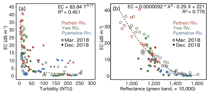
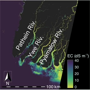
The imagery of Sentinel-2 was suitable for monitoring saline intrusion because of its high spatial (10-m) and temporal (10-day) resolutions. We found that the reflectance of the visible bands correlated with electrical conductivity (EC), which in turn was influenced by the concentration and composition of dissolved salts. When the river water mixed with salt water from the sea, suspended particles tended to flocculate and settle, indicating that less turbid water was more saline. The best-fitting model was obtained with the green band (coefficient of determination R2 of 0.78, root mean square error of 4.90 dS m-1, and mean absolute error of 3.34 dS m-1). The saline intrusion, which showed considerable spatial and temporal variability during the dry season, extended approximately 80 km inland at the end of the dry season in March at Pathein River. The 1 ppt salt concentration line in March marked the boundary between cultivated and non-cultivated areas of the paddy field, indicating that cultivable areas were strongly affected by saline intrusion. The results show that more frequent monitoring and use of higher resolution Sentinel-2 image data can support effective water resource management.
Figure, table
-

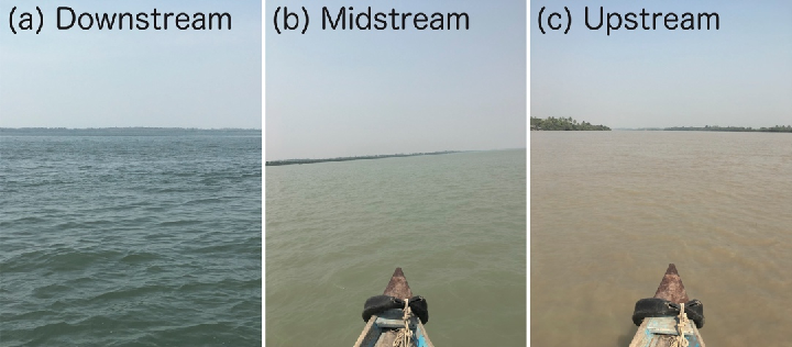
Fig. 1. Photographs of river water conditions in the (a) downstream, (b) midstream, and (c) upstream reaches of Ywe River on 9 March 2018
-
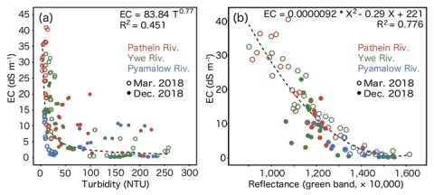
Fig. 2. Relationships between (a) turbidity and electrical conductivity (EC), and (b) EC and green band reflectance retrieved from Sentinel-2
-

Fig. 3. Spatial distribution of EC on 12 March 2018
-
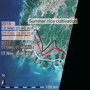
Fig. 4. The 1 ppt salt concentration lines during the dry season
The lines connect locations where EC is 1.56 dS m-1 (i.e., 1 ppt).

- Affiliation
-
Japan International Research Center for Agricultural Sciences Social Sciences Division
Japan International Research Center for Agricultural Sciences Research Planning and Partnership Division
- Classification
-
Research
- Research project
- Program name
- Term of research
-
FY2020(FY2016~FY2020)
- Responsible researcher
-
Sakai Toru ( Social Sciences Division )
Omori Keisuke ( Research Planning and Partnership Division )
Oo Aung Naing ( Yezin Agricultural University )
Zaw Yan Naung ( Department of Agriculture, Myanmar )
- ほか
- Publication, etc.
-
https://doi.org/10.1007/s10333-020-00837-0
Sakai T et al. (2020) Paddy and Water Environment
- Japanese PDF
-
2020_A03_A4_ja.pdf691.66 KB
2020_A03_A3_ja.pdf596.47 KB
- English PDF
-
2020_A03_A4_en.pdf505.68 KB
2020_A03_A3_en.pdf506.91 KB
- Poster PDF
-
2020_A03_poster.pdf498.84 KB
* Affiliation at the time of implementation of the study.