Changes in distribution of paddy fields in the Heilongjiang Province of China detected using satellite data MODIS
Description
The Heilongjiang Province is one of the major Japonica rice producing areas in China and the rice planted areas of this province have increased largely since the mid-1990s. In recent years, the acreage of rice-planted areas show considerable variation year by year based on the statistical data per province. However, distribution details could not be analyzed due to the lack of information in adequate spatial context. This study is aimed at the development of a methodology to estimate the distribution of rice planted areas in a wider range such as on a provincial scale and to produce a dataset for further analysis on the characteristics of spatial and temporal changes using earth observation satellite data. Because of a limitation in the coarse spatial resolution of satellite data which could have enabled us to observe the same site frequently, this study attempted to estimate the percentage of target land use area per pixel in order to obtain more accurate information about acreage. We applied the developed method to the data from the year 2003 to 2008 and analyzed the spatial and temporal features of rice planted areas in the Heilongjiang Province.
We processed the reflectance of Band 1, Band 2 and Band 7 of the MODIS (Moderate Resolution Imaging Spectroradiometer) data, with spatial resolution of 250, 250, 500 meters respectively and produced cloud-free images representing ground surface conditions from late May to early June, which was generally the rice transplanting period in the Heilongjiang Province. A new index, NDBSI (Normalized Difference Bare Soil Index) calculated from Band 1 and Band 7, was introduced to discriminate waterlogged areas effectively. We combined this with NDVI (Normalized Difference Vegetation Index) and then obtained an indicator to estimate the percentage of rice planted areas per pixel. In the scheme of estimating rice planted areas, we discriminated the potentially confusing items such as open waters by adopting the characteristics of the seasonal changes of NDVI.
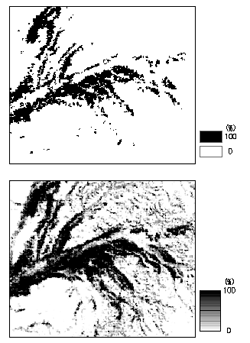
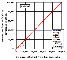
Accuracy of estimation was assessed by comparing the multi-level classification results of the satellite data with different spatial resolutions. The improvement in estimation accuracy was validated by the appearance of half tone parts in Figure 1, which could not be extracted from pixel-based classification. Comparison of aggregated acreages by province with the values obtained from Landsat data exhibited good correlation (coefficient of determination; R2=0.976) as shown in Figure 2.
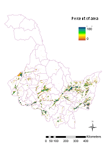
We calculated the percentage of the acreage of rice planted areas per pixel for the whole Heilongjiang Province from 2003 to 2008. Figure 3 shows the data of 2008. The distribution map indicated that the major rice planting areas are located in the portions along large rivers in the Central and Western side of the province as well as in the Sanjiang Plain in the Eastern side.
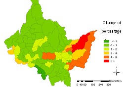
Several counties located in the Eastern and the Central parts showed higher rates of increases as measured by the changes of percentage per county for the period 2003 to 2007 (Figure 4).
Figure, table
-
Fig. 1. Comparison of the extracted data of rice planted areas between the pixel-based classification (upper) and the newly developed method (lower). -
Fig. 2. Comparison of the acreage of rice planted areas per province between values obtained from Landsat data (horizontal) and the developed method (vertical). -
Fig. 3. Distribution map of rice planted areas in the Heilongjiang Province estimated using the developed method (2008 data). -
Fig. 4. Changes in the percentages of planted acreage of paddy fields in Heilongjiang Province for the period 2003 to 2007.
- Affiliation
-
Development Research Division
- Classification
-
Technical A
- Term of research
-
FY2008(FY2004~2008)
- Responsible researcher
-
UCHIDA Satoshi ( Development Research Division )
JIAO Jiang ( Heilongjiang Provincial Academy of Agricultural Sciences )
- ほか
- Publication, etc.
-
Uchida, S. (2006) Development of rapid mapping method of paddy fields using satellite data applied to Heilongjiang Province in China. JIRCAS Working Report 50, 1-7.
Uchida, S. (2008) Journal of the Japanese Agricultural Systems Society 24(4), 207-215.
- Japanese PDF
-
2008_seikajouhou_A4_ja_Part3.pdf587.71 KB


