Countermeasures against freshwater lens pollution on atolls should consider the groundwater residence time
Description
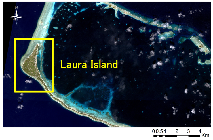
In Small Island Developing States (SIDS) where the land is formed by low-level atolls of up to several meters in height above sea level, vulnerable fresh groundwater lenses are often used as the main water resources. However, soil permeability in atoll islands is fairly rapid, and there is a high risk of groundwater pollution due to infiltration of domestic sewage from villages directly above and by drainage water from cropland and piggeries. Therefore, understanding the actual situation and taking measures for the effective management of water resources are necessary. A survey was carried out to assess the actual situation of nitrate-nitrogen (NO3-N) pollution in a freshwater lens in Laura Island, Majuro Atoll, Republic of the Marshall Islands (Fig. 1), and the pollution risk was estimated based on the nitrogen load from houses, piggeries, and cropland, which was calculated by multiplying household survey data by the reported nitrogen basic unit. Here we propose an effective way of managing the freshwater lens while applying countermeasures against groundwater pollution, taking into account the groundwater residence time.
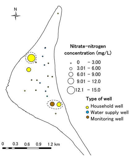
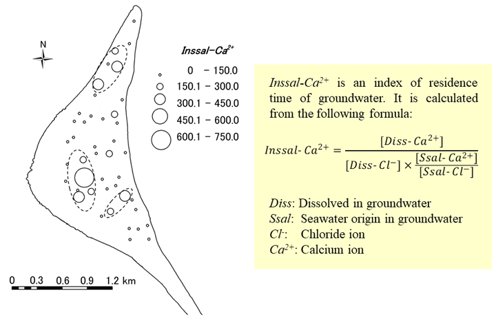
NO3-N concentration exceeded the WHO standard for drinking water (11 mg L-1) at one household well out of the 73 surveyed wells in the study area, with relatively high NO3-N concentrations noted in the southeast and northwest sides of the island (Fig. 2). Nitrogen load was estimated for each main source by multiplying the respective number of people and pigs and cropland area by basic unit (amount of N per unit). Sum of nitrogen emissions on the island was estimated in the following order (from largest): piggeries> houses> cropland, while the nitrogen emission per source was estimated to be in this order (from largest): piggeries> cropland> houses (Table 1). If the influence of human or volcanic activity is not large, it is noted that the concentration of non-sea-salt calcium ion dissolved in groundwater reflects on the length of groundwater residence time in the limestone area. Thus, we propose an original simplified index of groundwater residence time called Inssal-Ca2+ (Fig. 3). When all the groundwater is recharged from seawater, the value of Inssal-Ca2+ is 1. A higher Inssal-Ca2+ value indicates longer residence time of groundwater because it indicates the ratio of dissolved total calcium ion to expected sea-salt calcium ion. According to our results, Inssal-Ca2+ values of household wells in the open sea side and southern side of the island were relatively high. There is a high possibility that residence time of groundwater in these areas was relatively high. Countermeasures are required in consideration of the protracted pollution of groundwater.
The maximum NO3-N concentration of groundwater at the study area was 13.0 mg L-1, which exceeded the drinking water criterion by WHO. Due to this fact, the amount of nitrogen emission load to underground should be reduced. The results of this study will be used as basic data to consider reduction of nitrogen load seeping underground and contributes to efficient implementation of the countermeasures. Inssal-Ca2+ is a simple method; it is recommended that groundwater residence time is evaluated by multiple analyses (e.g. tritium, chlorofluorocarbons, sulfur hexafluoride) of multiple points.
Figure, table
-
Fig. 1. Laura Island of Majuro Atoll in Republic of the Marshall Islands
-
Fig. 2. Nitrate-nitrogen concentrations of groundwater in Laura Island (Feb. – Mar. 2011)
-
Fig. 3. Inssal-Ca2+ values of groundwater in household wells (Jul. - Aug. 2011)
-
*[Unit nitrogen emission] Houses: one house, Piggeries: one piggery, Cropland: parcel of croplandTable 1. Nitrogen loads from houses, piggeries and cropland in Laura Island Houses* Piggeries* Cropland* Sum of nitrogen emissions
(N g/day)16,000 18,000 9,200 Average nitrogen emissions
(N g/day)70 210 120 Maximum nitrogen emissions
(N g/day)310 5,100 2,200 Percentage of each nitrogen source to total nitrogen emissions from anthropogenic sources
(%)37 42 21
- Affiliation
-
Japan International Research Center for Agricultural Sciences Crop, Livestock and Environment Division
- Research project
- Program name
- Term of research
-
FY2018 (FY2011-FY2015)
- Responsible researcher
-
Iizumi Yoshiko ( Crop, Livestock and Environment Division )
KAKEN Researcher No.: 00414996Omori Keisuke ( Rural Development Division )
MIERUKA ID: 001793Nitta Naoto ( Japan Association for International Collaboration of Agriculture and Forestry )
- ほか
- Publication, etc.
-
https://doi.org/10.4145/jahs.48.81
Iizhumi Y. et al. (2018) Journal of Japanese Association of Hydrological Sciences 48(2):81-93
- Japanese PDF
-
A4766.16 KB
A3342 KB
- English PDF
-
A4386.63 KB
A3502.48 KB
- Poster PDF
-
2018_A07_poster.pdf485.92 KB


