Sustainable groundwater utilization map in the salt-affected area in Northeast Thailand
Description
Promoting the alternative utilization of groundwater is among the methods available to mitigate water shortages. Such shortages are a major impediment to agricultural production in Northeast Thailand. In this study, we intended to conduct a survey on the level and quality of groundwater in the part of the Ban Phai Basin which is located in Khon Kaen Province and within which the village of Nong Saeng is located. We will develop a sustainable groundwater utilization map using the distributed groundwater flow simulation model. We hope that this will contribute to the formulation of guidelines for the utilization of groundwater for agriculture.
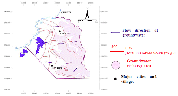
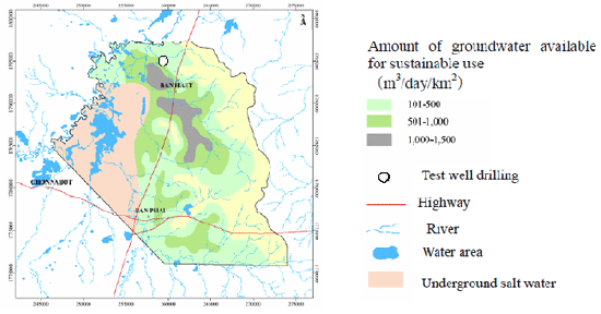
We selected the Ban Phai Basin in the Khon Kaen Province in Northeast Thailand as our test area. The altitude is high on the east side of the basin and decreases in a westward direction. We conducted our survey following three procedures: (1) Collection of information on soil, terrain, geology and land utilization in addition to the field study; (2) Measurement of the level and quality of the groundwater below the surface in the existing boreholes and newly constructed boreholes; and (3) Calculation of sustainable groundwater utilization using the distributed groundwater flow simulation model. Rainwater that infiltrates the plateau is the main source of groundwater in this area. Extensive amounts of groundwater flow from east to west. Where water discharges to the west, there is a salt-affected area in which the total dissolved solids (TDS) exceed 2,000 mg/L. It will be necessary to construct a system for complete drainage here to prevent salt deposits from accumulating in this area. The groundwater in this area serves only to supplement irrigation in the monsoon season and as cleaning water (Fig. 1). Using the distributed groundwater flow model, we can calculate the groundwater recharge for the entire basin as about 1.82x10⁵ m3 (from Oct. 2006 to Aug. 2007). We defined usable sustainable groundwater as that which has a TDS below 2000 mg/L and maximum pump displacement below 5 m over the next 10 years. We classified the target basin into four areas based on sustainable groundwater utilization, namely, 0-100, 101-500, 501-1000, and 1001-1500 m3/d/km2. These cover areas of 108 km2, 118 km2, 87 km2, and 24 km2, respectively (Fig. 2). In the dry season between January and April, we can grow crops by excavating a well (34 m deep) in the farmland near Chi River (see Fig. 2 for excavation/drilling point of the test well). Areas with more than 500 m3/day/km2 of sustainable groundwater utilization exist in the central part of the basin. In these areas, groundwater is promising as an auxiliary water source for rice growing in the monsoon season, as well as the water source for other crops in the dry season and for other water uses of the local population.
It is reasonable to believe that if similar procedures of this study are followed, other areas would yield the same information as obtained in this test area. Therefore, our results are applicable as well to groundwater utilization all over the entire area of Northeast Thailand. We used the three-dimensional finite difference groundwater model software (MODFLOW) to calculate the groundwater distribution flow simulation model. The cause of the high TDS in the groundwater of the salt-affected area is believed to be the passage of underground water through the rock salt beds at about 100 m below the ground surface. Clarification of the detailed mechanism involved in this phenomenon is an issue for future research.
Figure, table
-
Fig. 1 Groundwater movement in Ban Pau Basin in Khon Kaen province, Thailand -
Fig.2 Distribution of available groundwater for sustainable use in the research area
- Affiliation
-
Japan International Research Center for Agricultural Sciences Crop Production and Environment Division
- Classification
-
Technical A
- Term of research
-
FY2008(FY2006~2008)
- Responsible researcher
-
SRISUK Kriengsak ( Khon Kaen University )
SENCHAI Prayuth ( Khon Kaen University )
HAMADA Hiromasa ( Crop Production and Environment Division )
Sukchan Somsak ( Land Development Department, Ministry of Agriculture and Cooperatives Department, Thailand )
- ほか
- Publication, etc.
-
Srisuk, K., Senchai, P. and Hamada, H. (2008) Groundwater safe yield evaluation for agricultural usage in Ban Phai Subwatershed. Proceedings of the 3rd International Symposium on Sustainable Development in the Mekong River Basin. September 11-12, 2008, Khon Kaen, 217-224.
- Japanese PDF
-
2008_seikajouhou_A4_ja_Part14.pdf640.79 KB


