Difficulty in restoring salinized freshwater lens, a valuable water resource of atoll islands
Description
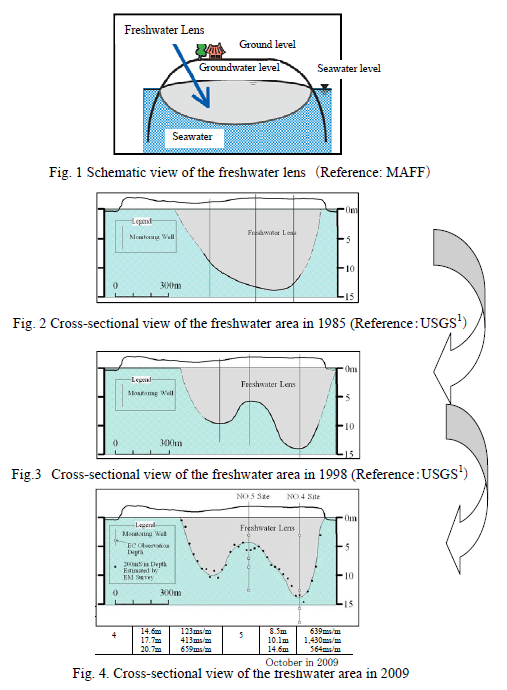
There are approximately 30,000 islands in the Pacific Ocean, in which about 1,000 islands are populated and are mostly located in developing regions. Among the islands of these small islands countries which are mainly low-lying atoll islands with small areas, with an elevation of a few meters on average, water resources are very fragile. The freshwater lens is defined as the freshwater area which floats, due to the differences in the density of freshwater and seawater, in the upper part of the aquifer layer over seawater in the lower layer in small islands, as shown in Fig.1. Water resources in low-lying small islands, where the water source depends on the freshwater lens, are considered to be susceptible to the reduced amount of recharge caused by the increased intake and drought etc. as well as further salinization due to the sea level rise resulting from global warming. It has become necessary to develop a conservation technology for the freshwater lens. Thus, we investigated the situation of groundwater salinization through a field survey in Laura Island, Majuro Atoll, the Republic of the Marshall Islands (RMI), where the freshwater lens has evolved, as a test case example.
In October, 2009, we observed the electric conductivity of the groundwater at existing groundwater monitoring wells by means of electro-magnetic survey along the survey line. We also estimated the boundary depth between the freshwater lens and the saltwater along the central survey line of the freshwater lens in Laura as well. The freshwater lens in Laura was shaped in the form of a lens according to the survey conducted by USGS (United States Geological Survey) in 1985 (Fig.2). Then, the partial rise on the boundary between the freshwater lens and the saltwater (up-corning) was observed by a groundwater survey conducted after the drought in 1998 (Fig. 3). The rainfall amount during the drought period (from January to April) was 71.7 mm, and the maximum number of consecutive dry days was 95, which means that there was scarce rainfall. The water sources for the residents during the drought period were the water obtained from the seawater desalination plant and the groundwater taken from the freshwater lens. This intake caused the up-corning from the bottom around the intake facilities in Laura. The cross-sectional shape of the freshwater lens which was identified as a result of the survey is shown in Fig.4. Thick lens at both sides and the up-corning at the central part can be seen. The results of the electromagnetic survey indicated that the whole shape of the freshwater lens is almost the same as the one in 1998.
We made use of the field weather observation data etc. to calculate the water balance. By assuming the annual average rainfall for the past four years (2006 to 2009) to be 2,900 mm, evapotranspiration of 1,260 mm/year derived by the use of Linacre equation, average annual intake of 62,000 tons/year, and the surface runoff of 0, the annual average rainfall infiltration to the underground is approximately 3.4 million tons. The storage volume of the freshwater lens is roughly estimated to be 1.86 million tons based on the result of the electromagnetic survey. Although the groundwater accounting for about 1.8 times the storage volume of the freshwater lens was supplied on an average annual basis, the up-corning of seawater which was observed in 1998, is being observed in 2009 as well. It has been proven to be difficult to restore a salinized freshwater lens. We confirmed that the salinized freshwater lens in Laura could not be restored from the up-corning despite a large amount of rainfall.
The situation of the continuous up-corning was provided a visible form on occasions such as seminars in which concerned administrative officers of the RMI government took part, so that the importance of the conservation of the freshwater lens was clearly recognized. To achieve the sustainable use of groundwater without salinizing it in the future, it is necessary to establish a stable intake method based on a calculation of available intake volume after modeling the groundwater flow, and to establish a groundwater monitoring system, etc. under the adequate management of the RMI government.
Figure, table
- Affiliation
-
Japan International Research Center for Agricultural Sciences Rural Development Planning Division
- Classification
-
Research
- Term of research
-
FY2007~2011
- Responsible researcher
-
KOBAYASHI Tsutomu ( Rural Development Planning Division )
KODA Kazuhisa ( Rural Development Planning Division )
MANPUKU Yuzo ( Rural Development Planning Division )
ISHIDA Satoshi ( Institute for Rural Engineering, NARO )
YOSHIMOTO Syuhei ( Institute for Rural Engineering, NARO )
- ほか
- Publication, etc.
-
Ishida et al. (2010) the Japanese Geotechnical Society 58(5):22-25.
- Japanese PDF

