Improving airborne LiDAR-based mangrove aboveground biomass estimation in the Philippines
Related Research Project
Yama-Sato-Umi agroecosystem connectivity
Country
Philippines
Description
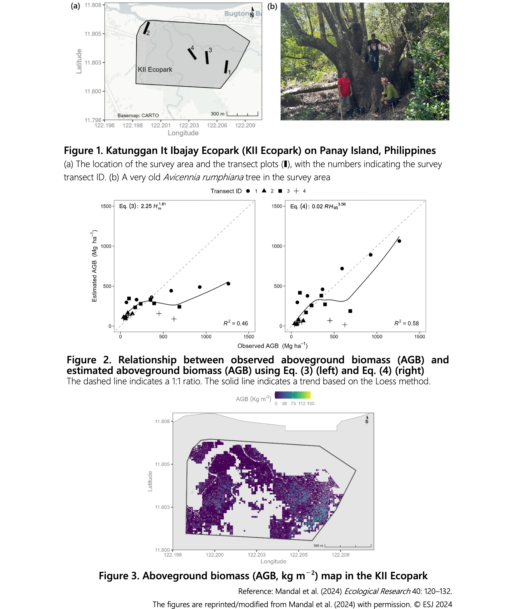
Monitoring mangrove biomass is crucial for evaluating carbon storage, understanding carbon cycles, and studying climate change. Traditional estimation methods often underestimate biomass due to regional variations in species composition and tree height. LiDAR technology, which measures distances and shapes using laser light, allows for non-destructive, extensive biomass estimation. The study aimed to develop a biomass estimation formula for old-growth mangrove forests in the Philippines using national-level airborne LiDAR data and focused on improving the accuracy of biomass estimation models.
The Lorey’s mean canopy height (Hm) and LiDAR relative height (RH) metrics were calculated for the old-growth mangrove forest in the Katunggan It Ibajay Ecopark (KII Ecopark) on Panay Island, Philippines (Fig. 1). The RH metrics were used to estimate Hm and above-ground biomass. Using the RH metrics, aboveground biomass was estimated in two ways: (i) Conventional method: Using the optimal RH, Hm was estimated, and then aboveground biomass was estimated using an existing formula (Suwa et al. 2021), and (ii) Developed equation: The newly developed equation directly estimates aboveground biomass using the optimal RH metrics. The relationship between Hm and the RH was verified, and then the conventional formula (above-ground biomass = 2.25Hm1.81 (Eq. 3) was applied to estimate above-ground biomass. The relative height at the 95th percentile (RH95) corresponded best with Hm (R2 = 0.79). When RH95 was applied to Eq. 3, above-ground biomass was underestimated in plots with high canopy height (R2 = 0.46) (Fig. 2, left). The formula for estimating above-ground biomass using RH95 showed relatively high accuracy (Fig. 2, right: above-ground biomass = 0.02*RH953.56 (Eq. 4), R2 = 0.58). The above-ground biomass map of the old-growth mangrove forest in KII Ecopark can be obtained using the developed Formula 4 (Fig. 3).
The newly developed equation is expected to enhance biomass measurement in old-growth mangrove forests, enabling extensive and correct assessments using airborne LiDAR data. This can contribute to measurement, reporting, and verification (MRV) processes, although incorporating additional variables, such as tree diameter, could further improve accuracy. The study highlights the importance of advanced methods for better understanding and managing mangrove ecosystems in the context of carbon storage and climate change.
Figure, table
- Research project
- Program name
- Term of research
-
FY2024
- Responsible researcher
-
Mandal Mohammad Shamim Hasan ( Forestry Division )
ORCID ID0000-0002-2696-0021Suwa Rempei ( Forestry Division )
ORCID ID0000-0003-4401-5581KAKEN Researcher No.: 40535986 - ほか
- Publication, etc.
-
Mandal et al. (2024) Eco. Res. 40(2), 120-132.https://doi.org/10.1111/1440-1703.12503References: Suwa et al. (2021) Est. Coast. Shelf Sci. 248, 106937.
- Japanese PDF
-
2024_A09_ja.pdf1.67 MB
- English PDF
-
2024_A09_en.pdf643.83 KB
* Affiliation at the time of implementation of the study.