Evaluation of rainfall station networks in tropical monsoon areas
Description
[Objectives]
Large-scale irrigation projects consisting of reservoirs contribute towards stabilizing rainy season rice cropping in Southeast Asia, but the water storage capacity of some reservoirs is not sufficient for double cropping. Therefore it is necessary to promote appropriate release reduction by monitoring the average amaunt of rainfall in irrigation systems. This study aims to propose a method for evaluating rainfall station density.
[Results]
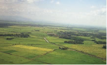
The study was carried out in the Muda Irrigation Scheme located in the northwestern region of Peninsular Malaysia (Photo 1). It covers an area of 126,000 ha, of which 96,000 ha consists of rice fields.
First, the spatial variability of rainfall was investigated in the target area. In this study, the simplified Horton method was used. Although the equation is very simple, it accurately portrays the spatial variability of rainfall because rainfall caused by convective lifting is predominant in the tropical monsoon area.
The next step was the simulation of rainfall events with specified rainfall over an area in which rainfall stations were evenly scattered. Accuracy of observation for simulated rainfall events under the given station density was calculated, and the relationship between the accuracy of observed rainfall and rainfall station density was obtained after appropriate simulations.
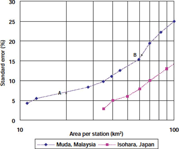
Standard error of rainfall as a function of station density in the Muda Irrigation Scheme is shown in Fig. 1; the evaluation of the rainfall station network implemented in Isohara by the Meteorological Agency of Japan is shown for comparison.
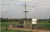
The rainfall station network began with 20 stations and has expanded to 61 stations in the Muda Irrigation Scheme (Photo 2). The effects of this further investment are not yet readily apparent, but Fig. 1 shows that the expansion of the network has improved the accuracy of rainfall observations.
Figure, table
-
Photo 1. Aerial view of the Muda Irrigation Scheme. -
Photo 2. Rainfall station equipped with a VHF radio. -
Fig. 1. Standard error of rainfall events as a function of station density.
A: Present station density; B: Initial station density
- Affiliation
-
Japan International Research Center for Agricultural Sciences Crop Production and Environment Division
- Classification
-
Technical B
- Term of research
-
FY2001 (FY1998-2001)
- Responsible researcher
-
HORIKAWA Naoki ( Crop Production and Environment Division )
- ほか
- Publication, etc.
-
N. Horikawa (2002): Evaluation of rainfall station network for irrigation projects in tropical monsoon area (in Japanese). Applied Hydrology, 15, 54-58.
- Japanese PDF
-
2001_12_A3_ja.pdf598.74 KB
- English PDF
-
2001_09_A4_en.pdf70.25 KB


