Farmers’ rainfall and cropping calendars: a tool for understanding inter-annual and intra-annual rainfall variability and assisting crop planting decisions
Description
Rainfed agriculture in the Sahelian region of West Africa is characterized by unstable production due to rainfall variability. Farmers are risk-adverse, input use is low, and yield levels are low. One cause of risk-adverse farmer behavior is spatial and temporal variability within the same year among farmers’ fields, but the degree of this variability is not well documented. Better understanding of farmer cropping decisions in response to rainfall variability and the development of a decision-support system to help farmers make better decisions based on cropping calendars are needed. For this reason, we developed a participatory monitoring and decision-support system called “Farmers’ rainfall and cropping calendars.”
Farmers in each village were selected through the following four-step participatory process over one week to reflect land use and farmer risk robustness. 1) An all-village meeting was held in which farmers drew their own land use map and farmer categories for soils, topography, and land use were delineated. 2) Farmer risk indicators were elicited through open questions, free responses, and matrix ranking in focus groups. Since there was no single word to express the concept of risk in the local language, risk was explained as “difficulties that we cannot know in advance when they will occur.” Characteristics which enable farmers to withstand such difficulties were elicited and used as indicators of risk robustness. These were written on the lefthand side of a large sheet of paper using symbols and local words. Each farmer in a given focus group placed a stone by the indicator he or she considered most important, and overall ranking was obtained by summation. 3) A rapid survey of these risk robustness indicators was done for all the farmers in the village, and a typology of farmers based on risk robustness was developed. 4) A second all-village meeting was held to select participating farmers. Risk robustness farmer types were arranged in rows, land use was shown in columns, farmers’ numbers from the census were placed in the intersecting cells, and farmers were selected proportionally. The entire village participated in selection, could see how the results were obtained, and so had a high sense of ownership of the selection process and results.
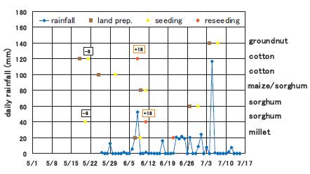
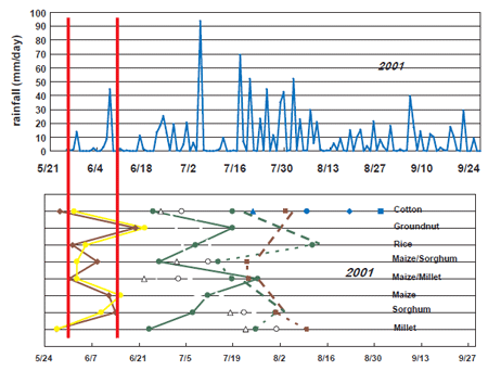
Rainfall measuring devices were then installed in the farmers’ fields to record daily rainfall. Dates of seeding and other field activities were recorded once a week. From these data, farmer-level calendars were constructed with rainfall amounts indicated on the left vertical axis, time indicated as days on the x-axis, and crops placed horizontally from the right vertical axis. On each crop line, the dates of its activities were indicated by their position relative to the x-axis (Fig. 1). Village-level calendars were constructed from individual farmer-level calendars to show average planting dates in relation to average rainfall for the village (Fig. 2).
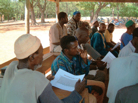
The above method was developed with 15 farmers in each of two villages in Mali over four years from 2001 to 2004, with the following results. 1) In the 800 mm annual rainfall semi-arid zone, in 2001, 57% of millet and sorghum parcels were seeded before there were two 10 mm rainfall events within 7 days, and 82% of these parcels required reseeding, such as with sorghum in Fig. 1. In 2002, farmers seeded 17 days later, with only 30% of the parcels seeded prior to the 2-event rainfall criteria, and reseeding decreased to 44%. 2) In the 1200 mm annual rainfall semi-humid zone, the rainy season is one month longer, so farmers traditionally waited several weeks later than the 2-event rainfall criteria to seed. Through the use of these calendars, over three years, farmers improved their seeding practices based on actual rainfall and thereby reduced unnecessary delays in seeding. Farmers were able to compare the village-level calendars with their individual farmer-level calendars (Photo 1) to gain anunderstanding of intra-annual and spatial variability.
In this research project, we used more expensive automated weather monitoring stations (about $600 each), but in Mali, simple rainfall gauges are now locally manufactured. These cost only about $30, including a stand, and the farmer can directly observe and measure the rainfall in the gauge. Through the use of this method based on “Farmers’ rainfall and cropping calendars,” farmers can build their own capability to monitor weather and cropping decisions. This can help farmers avoid reduced or delayed yields due to reseeding, resulting from seeding too early or due to later-than-necessary seeding, and thereby contribute to a more stable production under conditions of rainfall variability. This method is likely to be widely applicable throughout the Sahelian region of West Africa.
Figure, table
-
Fig. 1.
Example of a farmer’s individual rainfall and cropping calendar (number of days seeded prior to the first 10 mm rainfall and number of days reseeded after the first failed seeding). -
Photo 1.
Farmers comparing individual calendars while listening to a presentation of the village-level calendar. -
Fig. 2.
Example of a 2001 village-level rainfall and cropping calendar, semi-arid rainfall zone village, Mali.
- Affiliation
-
Japan International Research Center for Agricultural Sciences Development Research Division
- Term of research
-
FY2004(FY2000~2004)
- Responsible researcher
-
CALDWELL John S. ( Development Research Division )
OZAWA Kiyoshi ( Development Research Division )
SAKURAI Takeshi ( Development Research Division )
ORCID ID0000-0002-9007-4147KAKEN Researcher No.: 40343769BERTHE Abou ( Mali's Institute of Rural Economy )
DOUMBIA Mamadou ( Mali's Institute of Rural Economy )
YOROTE Abdouramane ( Mali's Institute of Rural Economy )
KANNO Hiromitsu ( Tohoku Agricultural Research Center, NARO )
SASAKI Kaori ( Tohoku Agricultural Research Center, NARO )
- ほか
- Publication, etc.
-
Caldwell, J., Berthé, A., Doumbia, M., Kanno, H., Ozawa, K., Yorote, A. Sasaki, K, Sakurai, T.(2002): Incorporation of farmer-based climate and risk indicators into research design and farmer typologies in southern Mali. Proceedings of the 17th Symposium of the International Farming Systems Association. CD or http://conference.ifas.ufl.edu/ifsa/papers/paper_c.htm, University of Florida, Gainesville, Florida, U.S.A..
Caldwell, J.S., Berthé, A., Kanno, H., Sasaki, K., Yorote, A., Ozawa, K., Doumbia, M., and Sakurai, T.(2005): Improved seeding strategies in response to variability in the start of the rainy season in Mali, West Africa. Japanese Journal of Agrometeorology, 60(5), 391-396.
- Japanese PDF
-
2004_02_A3_ja.pdf935.74 KB


