Ground-penetrating radar can predict the soil depth at which the petroplinthic horizon starts in the Sudan Savanna, West Africa
Description
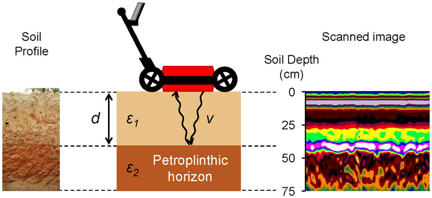
In the Sudan Savanna (annual rainfall: 600–900 mm), Plinthosols having a petroplinthic (PP) horizon are widely distributed. Because the PP horizon reduces soil volume and storage of water and nutrients, crop production in areas occupied by Plinthosols becomes limited. However, the distribution of Plinthosols has not been precisely known and conventional soil surveys require too much cost and effort. Therefore, at the Institute of Environment and Agricultural Research (INERA) Saria Station, Burkina Faso, we examined if ground-penetrating radar (GPR) can predict the soil depth at which the PP horizon starts or the top boundary of the PP horizon (d in Fig. 1). GPR is an equipment that can be used to detect soil interfaces that have abrupt boundaries and contrasting soil materials. In this study, effective soil depth is defined as the soil depth at which the PP horizon starts (d in Fig. 1) since only the soils overlying the PP horizon would contribute to crop production.
Our findings are as follows:
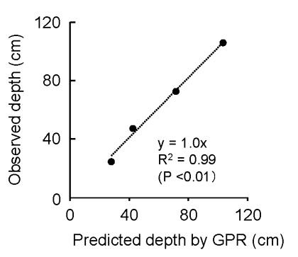
- Because relative permittivity of the PP horizon (ε2 in Fig. 1) is much higher than that of the overlying horizon (ε1 in Fig. 1), GPR can predict the top boundary of the PP horizon (Figs. 1 and 2).
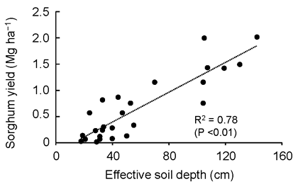
- Dominant soils in the Sudan Savanna (i.e., Ferric Lixisols, Petric Plinthosols and Pisoplinthic Petric Plinthosols) can be distinguished from the top boundary of the PP horizon (Ikazaki et al., 2018), and sorghum yield positively correlated with effective soil depth (Fig. 3). Therefore, maps of soil types and soil productivity can be easily created by using GPR (without conventional surveys).
- The top boundary of the PP horizon can be determined from a scanned image through a simple correction, enabling the procedure for making maps of soil types and soil productivity to become user friendly.
- Note that the above procedure can be applied only where the soil becomes very dry. This is because soil water having higher permittivity than PP horizons prevents GPR from detecting the top boundary of the PP horizon. This procedure may be applied to dry areas of Brazil and East Africa where PP horizons are widely observed.
With these findings, researchers studying soil and water conservation, fertilization methods, crop breeding, and so forth would be able to take greater account of the inherent soil conditions, which in turn would accelerate their studies for achieving sustainable agriculture in the Sudan Savanna.
Figure, table
-
Fig. 1. Schematic diagram of the detection of the petroplinthic horizon
The soil depth at which the petroplinthic horizon starts (d) can be estimated by converting the time it took the radar to travel from the surface to the boundary, assuming that the electromagnetic wave velocity in a vacuum is 3.0 × 10⁸ m sec‒1 and ε1 was 3.0. -
Fig. 2. Relationship between predicted depth and observed soil depth at which the petroplinthic horizon starts (d in Fig. 1)
-
Fig. 3. Relationship between sorghum yield and effective soil depth (d in Fig. 1)
- Affiliation
-
Japan International Research Center for Agricultural Sciences Crop, Livestock and Environment Division
- Research project
- Program name
- Term of research
-
FY 2018(FY 2016-FY 2020)
- Responsible researcher
-
Ikazaki Kenta ( Crop, Livestock and Environment Division )
ORCID ID0000-0001-5460-8570KAKEN Researcher No.: 70582021Nagumo Fujio ( Crop, Livestock and Environment Division )
KAKEN Researcher No.: 20399372Simporé Saïdou ( Environmental Institute for Agricultural Research, Burkina Faso )
Barro Albert ( Environmental Institute for Agricultural Research, Burkina Faso )
- ほか
- Publication, etc.
-
https://doi.org/10.1080/00380768.2018.1502604
Ikazaki K et al. (2018) SSPN, 64: 623-631
- Japanese PDF
-
A4293.47 KB
A3222.13 KB
- English PDF
-
A4172.43 KB
A3257.19 KB
- Poster PDF
-
2018_A04_poster.pdf314.69 KB


