Business Trip to Madagascar (June): Nobuhito Ohte, Professor, Kyoto University
Prof. Nobuhito Ohte of Kyoto University, a member of Output 4 of the SATREPS VaryAla Project, traveled to Madagascar in June to conduct field surveys and hold discussions with partner research institutions.
During this field trip, surveys were conducted in and around Ankarafantsika National Park to estimate the water balance of forested catchments and to characterize hydrological processes. Data were collected from, and maintenance was performed on, hydrological and meteorological monitoring equipment installed in the forested catchment and the burned catchment where observations have been ongoing since last year.
To compare canopy interception evaporation among forests with different vegetation conditions, two additional observation plots were established: one in a forest that had experienced a single fire event and another in a forest that had experienced two fire events. These were designated as the “One-burn” plot and the “Two-burn” plot, respectively, in addition to the “Primary Forest” plot where observations have been conducted since the year before last.
These plots were established outside the catchments where streamflow observations are being carried out because there was a high risk of theft of interception monitoring equipment, such as polyethylene tanks and hoses, within the forest catchment. Therefore, similar forest stands located near the center of the national park were selected as observation sites.
At each interception observation plot, the locations of throughfall and stemflow monitoring equipment were surveyed and mapped. In addition, a tree inventory survey was conducted, including the identification of tree species and measurements of diameter at breast height (DBH) and tree height, and a tree inventory list was compiled.
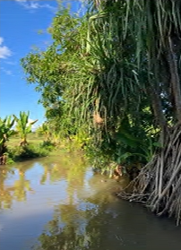
Furthermore, water-level gauges were installed at two locations downstream of the two hydrological monitoring catchments. One site was located in the Anjanojano-Fasika area, whose upstream watershed includes degraded forests outside the national park. The other site was located on the Kalambo River immediately downstream of the point where the river exits the national park, with the upstream watershed being almost entirely covered by forests within the park.
The field surveys were conducted in collaboration with researchers from the Laboratory of Radioisotopes (LRI), University of Antananarivo, a partner institution in this project. Discussions were also held regarding the continuation of hydrological monitoring and future plans for soil property investigations.
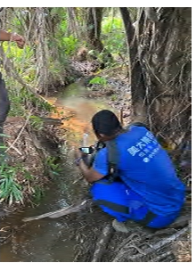
Water-level monitoring site in the Anjionofasika area