Feature abstraction of field boundaries and crop conditions by object-based classification using satellite imagery
Description
Along with the dissemination of high-resolution satellite imagery, object-based classification has attracted attention over the years. Object-based classification is accomplished by two steps, i.e. segmentation and classification. Segmentation is a process used to divide pixels into homogeneous spatial groups, and classification is a process utilized to determine the class of the group based on their feature values. It is a major advantage that various feature values representing texture and shape are available for classification. However, segmentation prior to classification is also important to produce a precise land use map. We proposed a manner to assign parameters for segmentation to identify agricultural land features, i.e. 1) field boundaries 2) growth uniformity, and 3) sowing/planting way, represented by QuickBird image observed in plantation area in Sumatra, Indonesia.
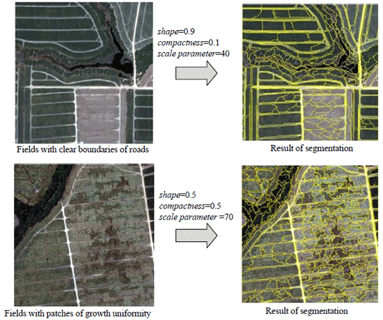
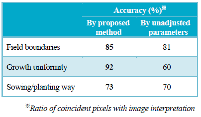
Segmentation was defined by three parameters. “Shape” defines homogeneity of the objects in term of morphological features and “compactness” is in irregularity. “Scale parameter” defines the size of objects. Values 0.1, 0.5, and 0.9 were respectively assigned to “shape” and “compactness”, then the best combination was selected by visual comparison through the nine pair-trials. Following the selection, the “scale parameter” coinciding with the size of the target was determined by exploratory trials. By this method, several heuristics for segmentation were obtained. For instance, it is appropriate to weigh “shape” and reduce “compactness” to classify road features representing field boundaries, and the assignment of intermediate values for “shape” and “compactness” in both is effective to show vegetation patches representing growth uniformity. By segmentation using the proposed method, classification accuracy was improved 3-32 points as compared with the results from segmentation with unadjusted parameters substituted by default values for multi-spectral satellite imagery.
Since the suitable form and size of objects are different per target, parameters have to be determined in each image. In this proposed manner, parameters are efficiently determined and they contribute toward improving classification accuracy. In addition, our results show that object-based classification is particularly suitable for identification of field boundaries and growth uniformity.
Figure, table
-
Fig.1. Sample images (Left) and the results of segmentation with adjusted parameters (Right). -
Table 1. Effect of parameter adjustment in classification accuracy
-
- Affiliation
-
Development Research Division
- Classification
-
Administration B
- Term of research
-
FY2008~2010
- Responsible researcher
-
YAMAMOTO Yukiyo ( Development Research Division )
HIRANO Akira ( Development Research Division )
UCHIDA Satoshi ( Development Research Division )
ABIDIN Zainal ( Indonesian Center for Agricultural Land Resources Research and Development )
- ほか
- Publication, etc.
-
Yamamoto et al. (2009) Proceedings of the Japan Society of Photogrammetry and Remote Sensing:3-6.
Yamamoto et al. (2010) Journal of the Japanese Agricultural Systems Society 26(Suppl 1):37-38.
Yamamoto et al. (201x) Journal of the Japanese Agricultural Systems Society (in printing)
- Japanese PDF
-
2010_seikajouhou_A4_ja_Part28.pdf483.84 KB


