Conformity of agricultural land use and physical stability in Khon Kaen, Northeast Thailand
Description
[Objectives]
In order to consider sustainable land use in Northeast Thailand, the land suitability for cultivation of major crops such as rice, sugarcane and cassava was evaluated based on physical factors, and the conformity of suitability with current land use was revealed using Geographic Information System (GIS) technology and a multitemporal satellite data set acquired by the LANDSAT-5/Thematic Mapper (TM). The study site was the area within 102°30' E-103°00' E and 16°00' N-16°30' N located in Khon Kaen Province.
[Results]
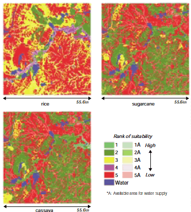
Land suitability for rice, sugarcane and cassava was determined by the assessment of soil properties and water resource availability (Fig. 1). The location of suitable areas for sugarcane and cassava overlapped in the hilly southeastern section of the site. Suitable land for rice was found in the lowland areas near the Chi River, which was unsuitable for upland crops.
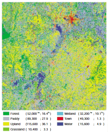
Land use map was produced using three TM data sets acquired in July 1989, October 1998 and March 1999 corresponding to the middle and the end of rainy season and the middle of dry season (Fig. 2). More than 60% of the study site was used for agriculture; 120,000 ha or 36% was upland crops and 90,000 ha or 28% was paddy.
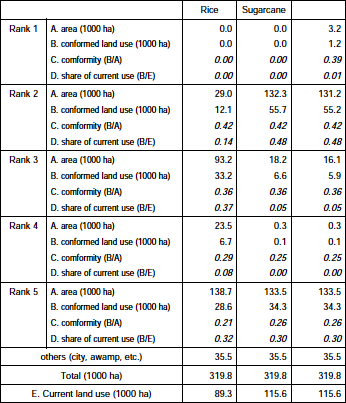
The conformity of land use and land suitability were shown by crossing operation in GIS (Table 1). The results were;
1) The suitable areas for sugarcane and cassava were more than 130,000 ha, but that for rice was only 30,000 ha.
2) Fields located in suitable areas were 55% upland crops and 12% rice in current land use area.
3) 40% of the suitable area was used for suitable crops but a large portion of the paddy fields were irrigated. Rainfed paddy located in suitable areas was very scarce.
Figure, table
-
Fig. 1. Land suitability for rice, sugarcane and cassava, evaluated by soil properties and water resource availability. -
Fig. 2. Land cover / land use map classified by PCA1&2 of TM8907, TM9810 and TM9903. -
Table 1. Conformity of land use and land suitability.
- Affiliation
-
Japan International Research Center for Agricultural Sciences Development Research Division
- Classification
-
Technical A
- Term of research
-
FY2001 (FY1998-2001)
- Responsible researcher
-
YAMAMOTO Yukiyo ( Development Research Division )
Sukchan Somsak ( Land Development Department, Ministry of Agriculture and Cooperatives Department, Thailand )
- ほか
- Publication, etc.
-
Y. Yamamoto and S. Sukchan (2003):Land suitability analysis concerning with water resource and soil property. JIRCAS Working Report (in press).
- Japanese PDF
-
2001_01_A3_ja.pdf1.84 MB
- English PDF
-
2001_01_A4_en.pdf173.53 KB


