Assessing the probability of land submergence for lowland rice cultivation in northern Ghana
Description
Sub-Saharan African countries are being strongly urged to enhance their rice production, because their rice consumption and importation rates have been rapidly increasing in recent years. Areas planted to rice in Africa are classified agro-ecologically into rainfed upland, rainfed lowland, and irrigated. Rainfed lowland includes extensive areas of unexploited land that has great potential for the promotion of rice-growing. To develop low-cost rice-farming systems that require no large-scale irrigation or land reclamation, it is important to select suitable areas where water for rice-farming can be obtained naturally; floodwaters offer promise for this purpose. Here, we propose a method of assessing flood probability from submergence frequency, as estimated from satellite imagery and geospatial data.
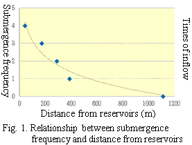
ALOS/PALSAR images acquired in May, June, August, and September 2010 were used to classify land and water, and then a submerged-area map was produced. In the study site, submergence frequency (y) was approximated by distance from reservoirs (x):
y = –1.281ln(x) + 9.0566 (R² = 0.9415) (Fig. 1)
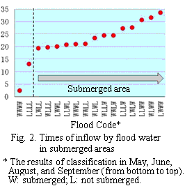
Flood extent derived from reservoirs was simulated using Digital Elevation Model (DEM) and the flood simulation program “SimFlood,” which was developed during the study. The results implied that the submerged areas identified by PALSAR were distributed in areas where flood water inflow exceeded 20 times (Fig. 2).
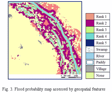
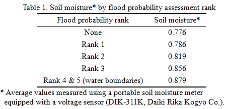
A flood probability assessment map was produced by integration of the estimated submergence frequency and flood extent simulation (Fig. 3). Validation of results using field monitoring data obtained in September 2011 confirmed the adequacy of the estimation (Table 1). Thus the possibility of floodwater use in the study area could be adequately determined.
The flood simulation program “SimFlood” is available for distribution in executable form. When DEM and water resources map can be prepared, the probability assessment of land submergence in other similar areas would be possible.
All-weather microwave sensors that can penetrate clouds have substantial advantages, particularly in identifying the extent of water resources during rainy season. ALOS/PALSAR has been inactive since April 2011, however, archived data are available for analysis.
Figure, table
- Affiliation
-
Japan International Research Center for Agricultural Sciences Social Sciences Division
- Classification
-
Administration B
- Program name
- Term of research
-
FY 2011 (FY 2011-FY 2015)
- Responsible researcher
-
Yamamoto Yukiyo ( Social Sciences Division )
Tsujimoto Yasuhiro ( Crop, Livestock and Environment Division )
ORCID ID0000-0001-7738-9913KAKEN Researcher No.: 20588511Fujihara Youichi ( Ishikawa Prefectural University )
KAKEN Researcher No.: 10414038Sakagami Junichi ( Social Sciences Division )
Fosu Mathias ( Savanna Agricultural Research Institute, CSIR, Ghana )
- ほか
- Publication, etc.
-
Yamamoto et al., (2012), Environment, Development and Sustainability, 14(6):955-971.
Yamamoto, et al. (2013), Tropical Agriculture and Development, 5(2):156-159.
- Japanese PDF
-
2012_13_A4_ja.pdf56.5 KB
- English PDF
-
2012_13_A4_en.pdf181.8 KB