Relationship between surface runoffs and water levels in farm ponds in the sandy, sloping farmlands of Northeast Thailand
Description
The sandy soils which are widely distributed in Northeast Thailand have high permeability and rainwater is supposed to easily infiltrate into the underground. Nevertheless, there are many farm ponds for pooling and storing surface runoffs in this region. In this research, we intend to estimate quantitatively the occurrence of surface runoffs in the sandy, sloping farmlands in Northeast Thailand and analyze the relationship between their occurrence and the water levels of the farm ponds.
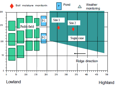
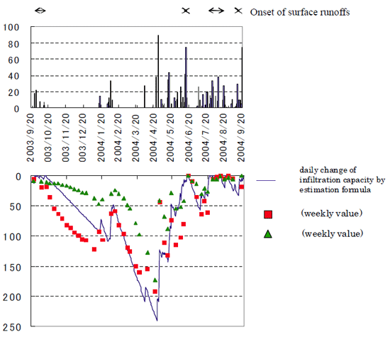
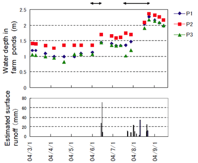
We selected the sandy, sloping lands of the village of Nong Saeng in the Khon Kaen Province of Northeast Thailand as the test area (Fig. 1). The lowlands in this area are used as paddy fields and the sloping lands are used to grow sugarcane. The gradient of the ground surface is about 3 degrees. As the groundwater level of the test area is lower than the bottom of the farm ponds, water in the farm ponds is unaffected by the groundwater. The soil of the test area is made up of an upper loamy sand (LS) surface layer with a depth of about 1 m (hereafter, referred to as LS layer). The hydraulic conductivity (HC) is in the order of 10-3-10-4 cm/s. Beneath this is a sandy clay layer (hereafter, referred to as SC layer). The HC is in the order of 10-6 cm/s. The rainwater in the LS layer is retained there because of low HC in SC. When the LS layer reaches saturation point, the amount of water is defined as the infiltration capacity. Beyond this, a surface runoff will occur. Surface runoffs occurred between September 20 and October 20, 2003; on June 17, 2004; between July 20 and August 20, 2004; and on September 20, 2004. The surface runoffs that occurred during the measurement period were calculated to amount to 374 mm that is close to 30% (Fig. 2). On mid-June and most of August a remarkable rise in the water levels of the storage reservoir was recorded. This roughly corresponded with the periods when surface runoffs occurred. As expected, surface runoffs and the corresponding rise in the water levels of the storage reservoir, occurred when rainwater in the LS layer exceeded saturation point (Fig. 3).
Although the monsoon season begins in April in Northeast Thailand, the water levels of the farm ponds rise considerably in mid-August, when the second part of the monsoon season begins. During the first half of the monsoon season, the farm ponds have lower water levels and insufficient amounts of water are available for irrigation. It is therefore necessary to formulate and implement a strategy whereby groundwater can be utilized as an auxiliary water source during the first half of the monsoon season.
Figure, table
-
Fig.1. Overview of the study site. (N: 16° 9′, E: 102° 48′) -
Fig. 2. Daily changes in infiltration capacity estimates.
Site 1: Weekly values, Site 2: Weekly values
X: the day when surface runoff took place -
Fig.3 Changes in water levels of the ponds and estimated surface runoff.
P3 is a pond located close to the study site.
⇔: the period when water level in the farm ponds rapidly rised.
- Affiliation
-
Japan International Research Center for Agricultural Sciences Crop Production and Environment Division
- Classification
-
Technical A
- Term of research
-
FY2008(FY2006~2008)
- Responsible researcher
-
WATABE Hiroki ( Ministry of Agriculture, Forestry and Fisheries )
HAMADA Hiromasa ( Crop Production and Environment Division )
MOROIZUMI Toshitsugu ( Okayama University )
Sukchan Somsak ( Land Development Department, Ministry of Agriculture and Cooperatives Department, Thailand )
- ほか
- Publication, etc.
-
Hamada, H., Watabe, H., Moroizumi, T. and Sukchan, S. (2008) Analysis of surface runoff in a sloping sandy soil in Northeast Thailand using soil water storage capacity. Journal of Japan Society of Soil Physics 109, 45-50.
Hamada et al. (2009) Journal of the Japanese Society of Irrigation, Drainage and Rural Engineering 77,25-28.
- Japanese PDF
-
2008_seikajouhou_A4_ja_Part15.pdf520.76 KB


