Development of a distributed hydrologic model for estimating rice production in northeast Thailand
Description
Rainfed rice cultivation in northeast Thailand is unreliable and suffers low yields. To obtain watershed-level perspectives for rice production with efficient water use, specific analytical tools are required. The objective of this study is to develop a distributed hydrologic model to execute rice yield prediction in a watershed level under rainfed conditions.
Nong Saeng Village, located 30 km south of Khon Kaen City, was selected as the study site. At the study site, hydrologic observations, measurements of soil property, and interview surveys on rice cultivation were conducted for modeling purposes. Spatial data such as land use surface gradients and flow direction were processed via ASTER satellite imagery at a grid size of 1.5 m. The hydrologic model has three layers for storing water, and can calculate water movements among grid cells in three dimensions for inputting daily rainfall data.
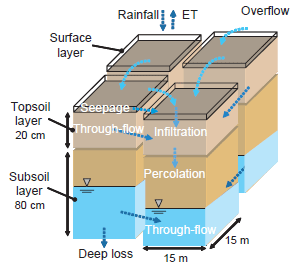
The hydrologic model calculates, on a daily basis, the water budget in all the grid cells of the watershed. The modeling site was divided into 15 m grid cells. The water budget and movement in each cell is expressed using a three-story set of storage layers (Fig. 1). The surface layer storage represents ponding depths in paddy fields or depression storage depths under other types of land use. Topsoil layer storage represents soilwater content from 0 to 20 cm depth and subsoil layer storage represents the shallow groundwater level from 20 to 100 cm depth. The model computes vertical water movements (infiltration, percolation, deep loss, and evapotranspiration (ET)) and horizontal water movements (overflow, seepage, and throughflow) in eight directions. The computations are executed from the upstream cells in the watershed.
The water conditions calculated in the hydrologic model are evaluated to predict rice yield in the rice yield sub-model. Rice yield is estimated from the yield reduction caused by water deficit at each growth stage. The sub-model estimates rice growth stages (vegetative, flowering, and yield formation) on the basis of the timing of transplanting. The heading date is more or less fixed, since farmers in northeast Thailand usually plant photosensitive rice cultivars; thus it can be estimated simply using an empirical equation. We assume a linear relationship between water deficits, namely, the ET ratio (actual ET/potential ET), and yield reduction in this sub-model. Because reduction of the growth period causes yield reduction, the period is also evaluated.
The parameter values were determined through simulation trials and field measurements; the same values were used for all calculations. Observed daily rainfall from April to December of each year at one station was used over the watershed as lumped input data in the calculations.
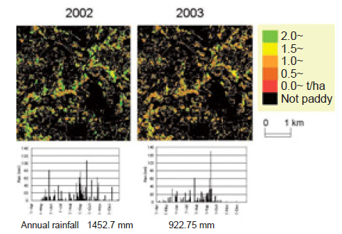
At the modeling site, we measured soil water content at 30 points in October 2003. The thus obtained data contributed to examining and deciding the parameters of the hydrologic model. From the water budget computed at the modeling site in 2002, runoff accounts for more than 50% of the water. These figures indicate that there is scope for improvement of water availability in the watershed.The results of an interview survey were used for the parameters of the rice yield sub-model, such as requisites for transplanting (earliest date: July 1, latest: September 20, minimum ponding depth: 50 mm) and attainable yield under actual conditions (3.1 t/ha). The combined model was applied to the simulation site and the rice yield was estimated for 2002 and 2003 (Fig. 2).
The results were in agreement with the actual status; the estimated yield in 2002 was higher than that in 2003. The proposed model proved to be an effective tool for analyzing the land and water resources of rainfed paddy fields. Although the model was developed specifically for the application site, it should be applicable to other similar watersheds in northeast Thailand.
Figure, table
-
Fig. 1. Hydrologic model structure. -
Fig. 2. Estimated rice yield at the simulation site.
- Affiliation
-
Japan International Research Center for Agricultural Sciences Development Research Division
- Classification
-
Technical A
- Term of research
-
FY2004(FY2002~2004)
- Responsible researcher
-
SUZUKI Kenji ( Development Research Division )
YAMAMOTO Yukiyo ( Development Research Division )
Sukchan Somsak ( Land Development Department, Ministry of Agriculture and Cooperatives Department, Thailand )
- ほか
- Publication, etc.
-
SUZUKI, K. and YAMAMOTO, Y. (2002) Hydrologic Model Analysis on Locations of Rainfed Agriculture in Northeast Thailand (I), Abstract of Annual Meeting of the Agricultural Engineering Society, 120-121.
SUZUKI, K. et al. (2002) Journal of the Japanese Agricultural Systems Society 18 (Suppl. 2), 79-80.
Suzuki K., Goto A., Mizutani M., Yamamoto Y., Sukchan S.(2003):Hydrologic Model of Rainfed Paddy Fields for Evaluating Small On-Farm Pond Irrigation in Northeast Thailand. 1st Int’l Conf. on Hydrology and Water Resources in Asia Pacific Region, Proceedings (Vol. 1), 462-466.
SUZUKI, K. et al. (2003) Hydrologic Model Analysis on Locations of Rainfed Agriculture in Northeast Thailand (II), Abstract of Annual Meeting of the Agricultural Engineering Society, 434-435.
SUZUKI, K. et al. (2004) Hydrologic Model Analysis on Locations of Rainfed Agriculture in Northeast Thailand (Ⅲ), Abstract of Annual Meeting of the Agricultural Engineering Society, 866-867.
- Japanese PDF
-
2004_04_A3_ja.pdf880.77 KB


