Production of a digital map of the hazardous conditions of soil erosion for the sloping lands of West Java, Indonesia using geographic information systems (GIS)
Description
[Objectives]
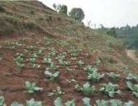
Soil erosion caused by precipitation is a kind of land degradation commonly appeared in the sloping lands of humid areas. In this study, we attempted to estimate the hazardous conditions of soil erosion by using geographic information systems (GIS). The study site used for this project was Langensari Village located in the Lembang Sub-District, Bandung District, West Java Province in Indonesia, where temperate vegetable fields were spread widely over the sloping highlands. Fig. 1 shows a typical scene of vegetable field in the site. We employed the Universal Soil Loss Equation (USLE) to estimate soil loss in the site. The objectives were 1) to develop a method to obtain factors used in the USLE from various geographic data including remote sensing data, and 2) to demonstrate the applicability of the system to land use planning.
[Results]
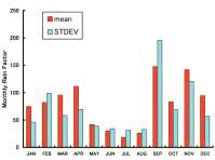
We developed a method to estimate rain factor (R) from the daily rainfall data. Fig. 2 shows the results of the estimated factor R during the period from 1990 to 2000. Soil factor (K) was calculated by using the results of physical analysis performed on soil samples taken from the site. Slope inclination factor (S) and the slope length factor (L) were obtained from digital elevation data produced by digitizing elevation contours on the 1:25,000 topographic map. In order to estimate the crop management factor (C), we analyzed three temporal remote sensing data and obtained the land cover/use data, which involved information from the cropping period. The conservation practice factor (P) was obtained by the values of texture features of aerial photos.
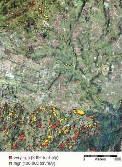
Fig. 3 shows the hazardous state of soil erosion represented by the 11-year averaged value for the period from 1990 to 2000. This figure represents that the erosion-prone area was concentrated in the southern part of the site. The methods employed in this study also enabled us to predict how the amount of soil loss would change if land use type or cropping pattern was altered. Table 1 summarizes the results of the calculation for the four patterns of assumed cropping, of which all the agricultural fields were cultivated simultaneously three times per year. This table indicates that the amount of soil loss differs remarkably depending on the sowing pattern. The amount of soil loss of Pattern 3 is far less than that of Pattern 1, presumably due to the effect of surface coverage by vegetation in September.
Figure, table
-
Fig. 1. A vegetable field located in the southern part of the study site. -
Fig. 2. Monthly rain factor showing mean and standard deviation (STDEV) estimated from daily rainfall data from 1990 to 2000. -
Fig. 3. Distribution of potentially hazardous areas of soil erosion expressed by the annual amount of soil loss. -
Table 1. Assumed cropping period and estimated annual soil loss in the Langensari Village area (388 ha).
- Affiliation
-
Japan International Research Center for Agricultural Sciences Development Research Division
- Classification
-
Technical A
- Term of research
-
FY2002 (FY2001-2002)
- Responsible researcher
-
UCHIDA Satoshi ( Development Research Division )
RITUNG Sofyan ( Center for Agricultural Land Research and Development )
KUNTJORO Dwi ( Center for Agricultural Land Research and Development )
- ほか
- Publication, etc.
-
Uchida, S. and Ritung, S. (2002): Estimation of USLE parameters by using remote sensing for the case of vegetable production area in West Java. Proceeding of Annual Conference Japanese Society Photogrammetry and Remote Sensing, 85-88 (in Japanese).
Uchida, S. (2002): Evaluation of hazardous conditions of soil erosion for the temperate vegetable production area in Indonesia using remote sensing data. Journal of the Japanese Agricultural Systems Society, 18, ext-2, 69- 70 (in Japanese).
- Japanese PDF
-
2002_01_A3_ja.pdf1.23 MB
- English PDF
-
2002_01_A4_en.pdf87.34 KB


