Development and publication of metadata in research information for the Fakara area in the Sahel, West Africa
Description
Since 1991, various researches have been actively conducted in the Fakara area of Niger by different international organizations like the International Livestock Research Institute (ILRI) and the International Crops Research Institute for the Semi-Arid Tropics (ICRISAT) based on the consensus of this area as a typical zone of the Sahel for mixed crops-livestock (agropastoral) system. JIRCAS has also joined in on this area since 2003 and started research activities through its overseas project on soil fertility management in sandy soils. Despite various researches conducted in the same area, the information obtained was not oriented towards the convenient access of others and this hampered the utilization of valuable sources of past information for the present or next research activities. In view of this situation, the information obtained by JIRCAS, ICRISAT and ILRI were compiled in metadata (MD) and opened to the public in order to improve accessibility to information and contribute towards future researches in the Sahel.
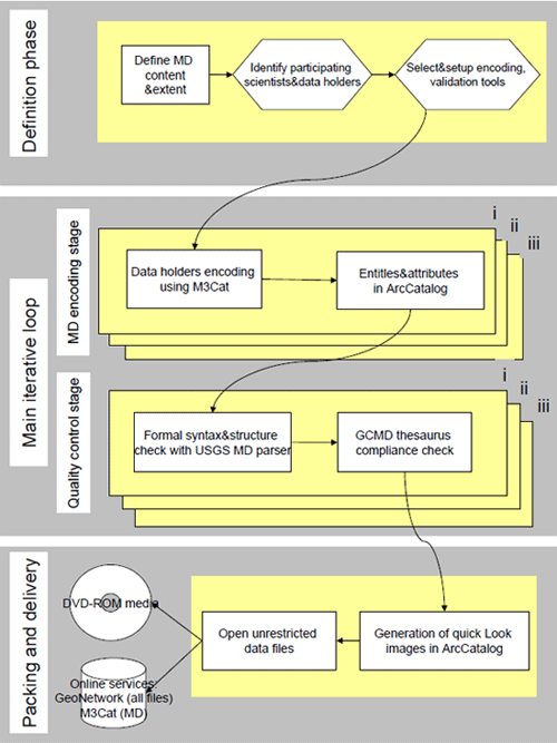
A workshop was organized initially at ICRISAT Niger with focal scientists and Geographic Information System (GIS) experts in order to decide the necessary procedures for an MD which comply with international standards. Three steps were taken for the procedure of the MD development, i.e. Definition phase (a variety of formats, sources, topics and disciplines), Main iterative loop (Data encoding and its verification), packaging and delivery (DVD-ROM media, online services).
Priority was given to encoding tools that helped simplify interactions with participating scientists (free, customizable and network-based) which met the widespread Content Standard for Digital Geospatial Metadata (CSDGM): M3Cat v. 1.5. For higher-level editing, ArcCatalog v. 9.0 was used.
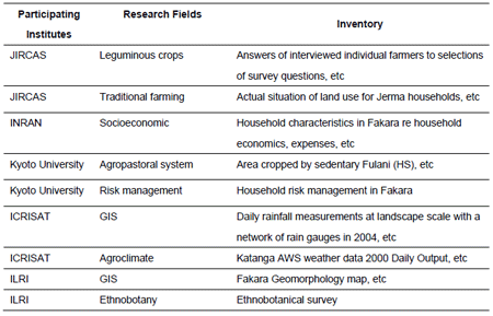
Past researches carried out in the Fakara area were compiled in this MD using the same format with sequential number, title, definition of information sources, origin of information, responsible scientist, contact address, a variety of format, data volume, etc. A dataset for geographical information contains satellite images with georeferences. A total of 73 datasets, including a dataset for geography, were stored in this MD, which contains an inventory of biophysical characterization collected by JIRCAS, satellite images and rainfall distribution data by ICRISAT, and land use information from 1950 collected by ILRI. The developed MD was saved on DVD-ROM and uploaded on the JIRCAS homepage for public uses: (https://www.jircas.affrc.go.jp/project/africa_dojo/Metadata/index.html).
Figure, table
-
Fig. 1. Flowchart for the documentation process of the Fakara MD -
Table 1. An example of the datasets in Fakara MD
(JIRCAS; Japan International Research Center for Agricultural Sciences, ICRISAT; International Crops Research Institute for the Semi-Arid Tropics, INRAN; Institute National de la Recherche Agronomique du Niger)
- Affiliation
-
Japan International Research Center for Agricultural Sciences Crop Production and Environment Division
- Term of research
-
FY2006-2007
- Responsible researcher
-
HAYASHI Keiichi ( Crop Production and Environment Division )
MATSUNAGA Ryoichi ( Crop Production and Environment Division )
TOBITA Satoshi ( Crop Production and Environment Division )
GERARD Bruno ( Crop Production and Environment Division )
LAOUALI Amadou ( Crop Production and Environment Division )
TRAORE Pierre Sibiry ( Crop Production and Environment Division )
AYANTUNDE Augustine ( Crop Production and Environment Division )
- ほか
- Publication, etc.
-
Documentation of ILRI/JIRCAS/ICRISAT Fakara data sets, JIRCAS Commissioned Research, https://www.jircas.affrc.go.jp/project/africa_dojo/Metadata/index.html
- Japanese PDF
-
2007_seikajouhou_A4_ja_Part10.pdf431.88 KB


