Satellite data analysis of vegetation trends in Mongolia on a national scale
Description
Mongolia is in East Asia, landlocked between Russia and China. It has an extreme continental climate with long, cold winters and short summers, during which most of its annual precipitation is received. Nomadism and animal herding have been central to Mongolian life for thousands of years, and herding is still the country’s main economic activity. This is why sustaining the well-being of vegetation, particularly grasslands, is of crucial importance to the nation. Since 1990, when Mongolia began a process of economic reform to phase out the state-controlled economic system in favor of a market economy, the number of domestic animals has been rising, risking serious overgrazing that risks nationwide degradation of vegetation. There are reports claiming that 30-70% of pastureland is already degraded, but opinion differs as to whether there is actually any significant degradation, and if so, how much.
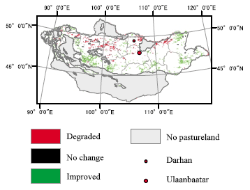
Satellite remote sensing technology has a distinctive advantage over other means of spatial information collection in that it obtains a synoptic view of ground features over large areas. In particular, data collected using multispectral sensors is often processed into a vegetation index for predicting and assessing vegetative characteristics such as percentage ground cover by vegetation, and general plant stress and vigor. One of the most commonly used vegetation indices is the normalized difference vegetation index (NDVI), whose values range between -1 and +1. The higher the NDVI value, the more and healthier the vegetation is expected to be at a given location. Using a time series Global Inventory Modeling and Mapping Studies (GIMMS) NDVI dataset (8 km resolution), we have depicted the spatial distribution of positive and negative vegetation trends over 23 years (1981- 2003) on a national scale. The results reveal that only about 12% of the national land area shows statistically significant long-term vegetation trends (3.1% negative; 8.7% positive) (Fig. 1).
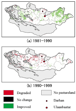
However, a closer look over the 10-year time periods before and after the political changes in 1990 indicates that negative trends have come to predominate during 1991-99 (4.6% negative; 1.7% positive), whereas it was the other way round during 1981-89 (1.6% negative; 12.2% positive). Contrary to common belief, no extensive vegetation degradation has been observed nationwide but localized degradation was in fact evident (Fig. 2). Our ground survey of hot spots and further assessments using higher resolution satellite data reveals that degradation is commonly observed around big cities (Ulaanbaatar and Darhan) and in abandoned croplands once heavily exploited under Soviet rule. It is also important to take into consideration the effect of ongoing global climatic change, but our findings shed light on specific areas that require immediate attention. Urgent technological development is required to prevent and mitigate further degradation in these problem areas.
Figure, table
-
Fig. 1. Spatial distribution of long-term vegetation trends (1981-2003). -
Fig. 2. Spatial distribution of vegetation trends over the 10-year time periods before and after the Fig. 1.
Spatial distribution of long-term vegetation trends (1981-2003). political changes in 1990.
- Affiliation
-
Development Research Division
- Classification
-
Technical A
- Term of research
-
FY2006(FY2006~2011)
- Responsible researcher
-
HIRANO Akira ( Development Research Division )
SHIMODA Katsuhisa ( Animal Production and Grassland Division )
TORIYAMA Kazunobu ( Animal Production and Grassland Division )
KOMIYAMA Hiroshi ( Development Research Division )
YAMASAKI Seishi ( Development Research Division )
ONIKI Shunji ( Development Research Division )
TUMENJARGAL Naran-Ochir ( Mongolian State University of Agriculture )
- ほか
- Publication, etc.
-
Hirano, A., Toriyama, K. and Komiyama, H. (2006): Spatiotemporal characterization of Mongolian grassland based on vegetation trend analysis. Proceedings of Asian Conference on Remote Sensing, CD-ROM.
Hirano, A. [Abstract of Autumn meeting of the Japan Society of Photogrammetry and Remote Sensing 2006], 105-108.
- Japanese PDF
-
2006_seikajouhou_A4_ja_Part13.pdf746.31 KB


